VISIT RUNYON CANYON
A RUSTIC CANYON MEETS THE INFAMOUS HOLLYWOOD HILLS. THIS IS RUNYON.
Since it's establishment as a public park in 1984, Runyon Canyon has served as an oasis from the rushed lifestyle of the big city.
Runyon Canyon welcomes close to 2 million tourists & locals yearly. It's a scene. Time for you to experience the absolute best Los Angeles has to offer. Please respect the surrounding neighborhood and park.

GETTING THERE
PARKING? NOT REALLY. SO LYFT/UBER, METRO, BIKE, OR WALK.
Directions:
South/Fuller Entrance--Hollywood Fwy (101) to Highland Avenue. South to Franklin Ave. West on Franklin to Fuller, north on Fuller to dead end. This is where everyone usually meets up - just inside the Fuller entrance.
For Waze or Google Maps enter:
2000 North Fuller Avenue
Los Angeles, CA 90046
Hours: Sunrise to Sunset, Daily
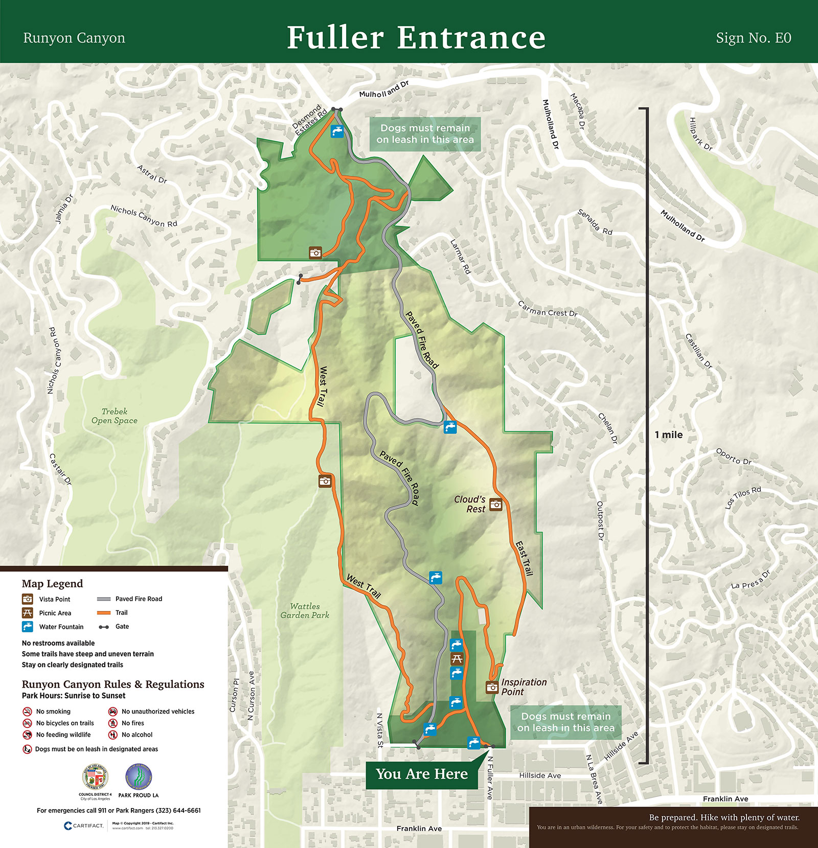
Map:

PARK ENTRANCE & TRAILS
WALK. HIKE. RUN. BRING YOUR DOG.
There are three ways to enter Runyon Canyon:
- Two entrances at the bottom of the park in the South: Fuller Entrance and Vista Entrance
- One at the top in the North: Mullholland Entrance
Click here for map. (If you have any amazing digital design skills, let us know! We need your help.)
Lower Route One
When entering at the bottom of the canyon the walker can choose to go round clockwise or counter-clockwise. Going clockwise involves gradually climbing up as one makes ones way towards the back of the canyon, swinging round to the east ridge to Clouds Rest and then coming down the steep slope and steps to Inspiration Point, before taking up the central fire road back down to the Fuller Ave entrance. Going counter-clockwise is a much more energetic climb up the steps and steep slopes between Inspiration Point and Clouds Rest, before the long and gentle road back down. Allow between 30-45 minutes for these routes.
Lower Route Two
There is the western trail which, from the southern approach at Vista, starts just inside the secondary gates (where dogs can be let off their leashes) and takes the hiker along the spine of the ridge to the second highest point in the canyon with magnificent views to the West and South. This is a considerably more taxing climb than the previous routes described and if followed by a descent via either the fire road or the eastern ridge route will take between 60-90 minutes. Taking in Indian Rock will add another 10-20 minutes.
Upper Route
Entering from Mulholland there are a couple of short hikes up Indian Rock to the highest point in the canyon with 360-degree views including the valley to the North. The alternative route follows the fire road round the rock and splits off towards the Western High Way or goes towards Clouds Rest and a choice of circuits.


